Hello skiers and snowboarders
Fall is coming quickly in the Northwest. Storms are becoming stronger and more frequent. Next week, looks like a robust start. The typical transition to the active stormy fall season is usually mid to late October, but sometimes it can get going a little earlier. The good news is; I am not seeing any stagnant large blocking high pressure zone for now. Grand Poobah is happy to see a progressive weather pattern so far, because a blocking high is the cause our extended dry spells.
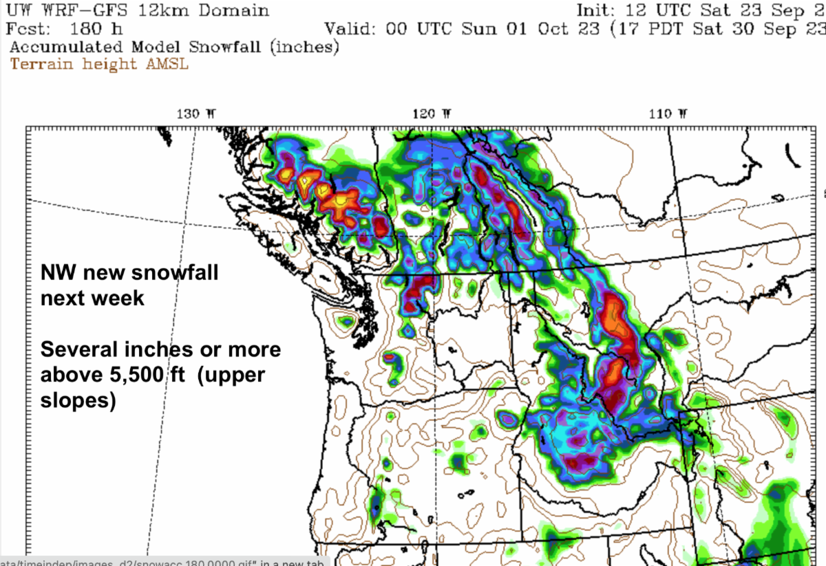
The Pacific weather machine in the Gulf of Alaska is beginning to awaken. Next week will see several strong storms with rainy conditions supported by an occasional modest atmospheric river attached to the storms for an extra punch of rainfall. Unsettled weather will be the rule. You’ll feel fall in the air. There will be a little snow in the higher elevations, but generally near the upper ski slopes. We will see light snow at 5,500 – 6,500 ft by weeks end. Do not expect much (if any) snow on the main ski slopes. Heavy rainfall will dominate the mid and lower elevations next week.
It's very early in the season. Normally, any snow which falls on the ski slopes in September or even most of October is meager and gets washed away or beat up in the next storm cycle by rain. Even early November can be plagued with a rain-snow mix. But on rare occasions it’s all snow, and we can have an early opening. A while back Crystal and Mt Baker (90’s) opened in late Oct and early November with several feet of early snow, but that is rare.
By November it’s cold enough for snow-making to augment the natural snowpack. Everyone is focused on opening near Thanksgiving. Whistler has already targeted an opening date of Nov 23, 2023. Typically, they are fairly reliable to partially open. I have skied Whistler with no natural snow. It was 100% snow making from Roundhouse to Village in early December a few years ago. To tell you the truth, it wasn’t bad – that’s a lot of vertical per run. Whistler alpine had limited natural snow at the time, but was skiable.
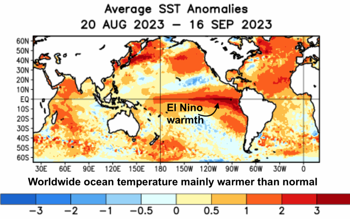
El Nino remains moderate and is forecast to strengthen. El Nino will often (not always) push us into a dry and mild winter pattern, as the storm track concentrates to the south into California. We saw that last season several times – even as last winter was the opposite, a La Nina. So you see, it's complicated. Sometimes it's not always a strong predictor. I do think we will have some occasional issues with high snow levels this winter - rain falling on our snowpack.
The warmth ahead is caused by three things: widespread global ocean temperatures above normal right now, El Nino warmth in the tropical Pacific and overall elevated worldwide temperatures, as the baseline climate slowly nudges warmer – as shown by observations and computer modelling.
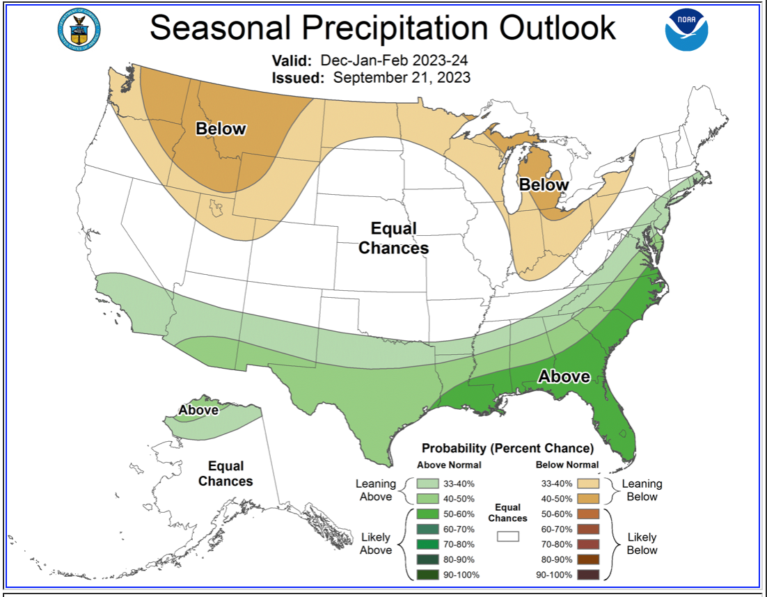
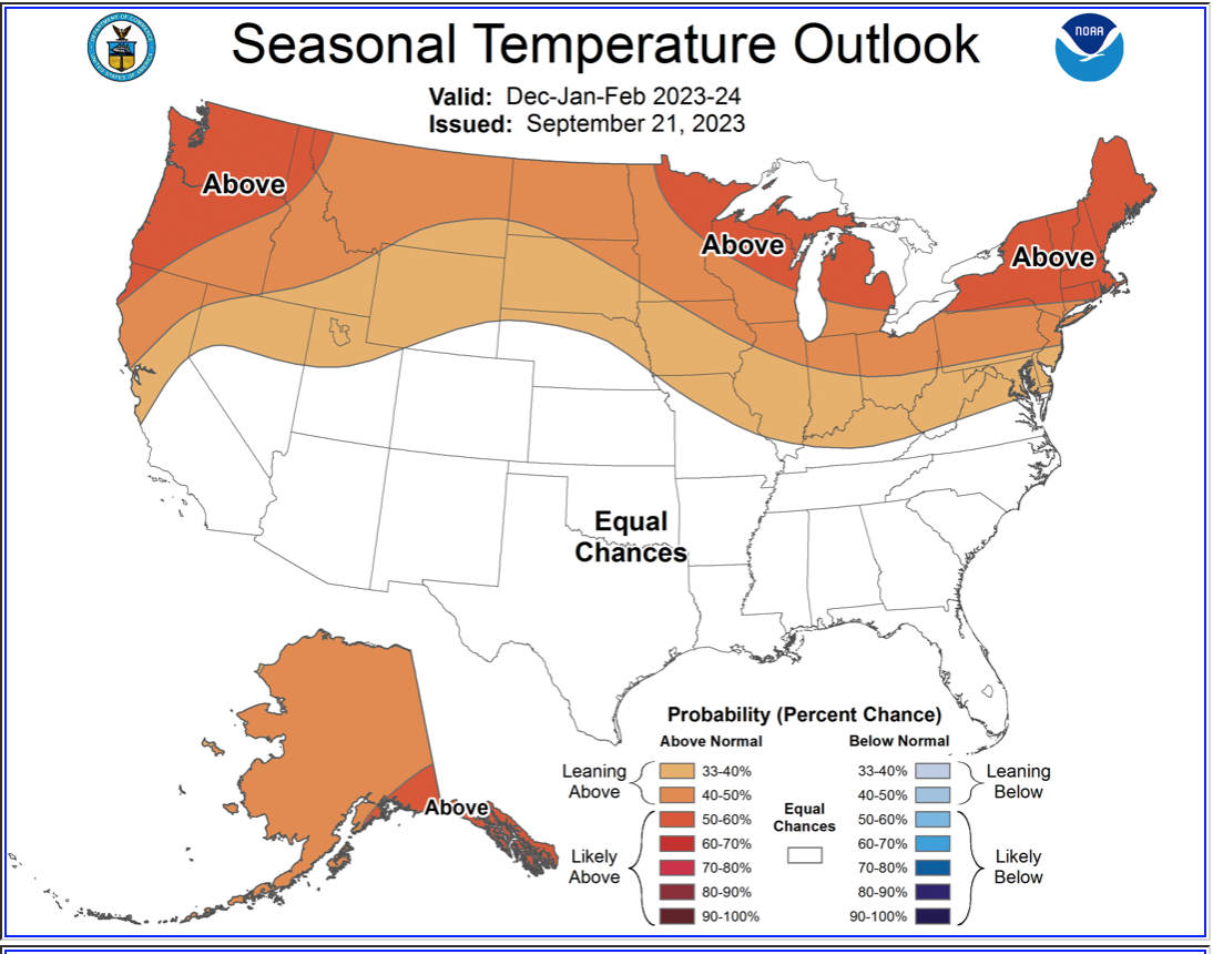
Those factors provide higher than normal confidence of warmth being an occasional problem with the NW snow this winter. But there will be good times. In the mix, we will see typical winter powder storms, but perhaps not as frequent. The snow pack will be near or shy of normal in many places…exactly where?...even the humble Grand Poobah does not know. The Inland NW may have challenges with thin early snowpacks too. Lower elevations in the entire NW may see spotty coverage especially in the early and again late season, as new snowfall tapers off. It means you must pay closer attention to the nuances of the Poobah's snow forecast especially with snow levels.
Bottom line: El Nino will have surprises. Whistler, Crystal, 49 Degrees, Silver Mountain and others will be helped with extensive snowmaking. For the most part it will remain cold enough for snow making. The start of the season will be uneven, about Thanksgiving or later. During the season, warmth (elevated snow levels) will occasionally be a problem. Also, especially in mid to late winter there will be dry spells, with the storm track aiming south. There will be skiing for all, just a bit more variable than typical.
Let the storms begin.
Please support our sponsors – they help keep this site and newsletter free for all… and free is a great price.
If you’d like to be a supporter and sponsor – contact myself. Would you be so kind as to address me as His Majesty the Grand Poobah -- as per Poobah Palace protocol? Or, contact: Andrea (Queen Bee) at powderpoobah@gmail.com.
Your Dear Leader and snow seeker,
Larry Schick – Meteorologist
The Exalted and Distinguished Imperial Grand Poohah of Powder
PS: Thanks to “Toast of the Playa” for her personal & generous donation to Outdoors for All in support of the "pay it forward declaration" from the Grand Poobah - may you be blessed with many a powder day!
"We should always be reminded of what we owe in return to what we have"
Here are your images for today's message from GPOP.