Hello skiers and snowboarders,


SHORT TERM:

For those that can sneak away to ski this Thursday, you can expect up to 6 inches of new snowfall by Thursday morning. The map below shows snowfall for the 24 hours ending Thursday morning. Many of the popular resorts in the West Cascades will get from 4 to 6 inches of snow (purple colors). White Pass should also get 4 to 6 inches. These snow totals are for 4000 feet and areas at 3000 to 4000 would see a snow and perhaps a rain mix at times. Areas above 4000 feet will get up to 10 inches of snowfall by Thursday morning.

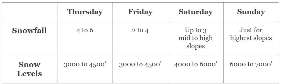
For Friday we are expecting 2 to 4 inches of snow at 4000 feet with a wintry mix of rain/snow below 4000 feet.


THIS WEEKEND

We will start to have some warming this weekend. The graph below shows temperatures at Stampede Pass, which is at 4000' and just east of Snoqualmie Pass. High temperatures of 37 by Sunday and warmer after that. Snow levels will be at 6000 to 7000 feet over the weekend with moderate rainfall at times for most of the ski slopes. This is definitely an El Niño signature, however we do see some changes in the extended outlook.


EXTENDED OUTLOOK

For much of the upcoming week from Monday, January 29 to Thursday, February 1 we will have warm temperatures with snow levels at 7000 feet at times. However, later on Friday, February 2 (map below) freezing levels drop to 3000 feet (light blue colors). Generally, snow levels are 1000 feet below freezing levels.

We will update you this Sunday.

Meteorologist Michael Fagin.


The Grand Poobah of Powder is out there on snow! Watch for Larry's updates.


The Woolly Winners... Eric, Lucas, and Charles.