Hello skiers and snowboarders,

Temperatures:

The map below reflects the current temperatures at 5 am Sunday, Jan 14, which factors in the wind, so we have the current windchill temperatures. The circled area is at Snoqualmie Pass. The air temperatures (not factoring in the wind) are:


  • Mt Baker 18
  • Blewett Pass -12
  • Stevens Pass -8
  • Snoqualmie Pass -5
  • Crystal Mountain (base) 15


This pattern can be found when we have the current conditions of modified arctic air mass in place. The main message is very cold temperatures in Eastern Washington, notice the temperature just east of Snoqualmie Pass on I-90, which is currently listed as -20 windchill. The other interesting fact is that when we have east winds like we do now, this drags the cold air from Eastern Washington and greatly impacts Stevens and Snoqualmie Passes.


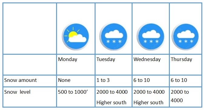
The good news on Monday is that while it will still be cold, temperatures will slowly start to warm up. Although afternoon winds start to increase, especially at Snoqualmie, to 15 to 20 mph.

Monday will bring dry conditions with sun breaks. Tuesday will start off dry and slightly warmer and then chances of light snow for later in the afternoon and more likely in the evening. Snow levels increase Tuesday evening and Wednesday morning more so for areas near Crystal Mountain and south. The higher snow levels are not likely for Snoqualmie Pass and Stevens Pass but if higher levels do occur, it could bring some brief periods of freezing rain. Not expecting this but it can occur under these conditions and tends to occur more often at Snoqualmie Pass vs. Stevens. Then Wednesday 6 to 10 inches (see map below) of snow and snow levels briefly go up early so perhaps a brief rain/snow mix but not likely. Finally, another 6 to 10 inches of snow for Thursday with snow levels at 2000 to 4000 feet.

Extended Outlook

The forecast for Friday through next weekend indicates warmer conditions with periods of precipitation. The forecast models are suggesting higher snow levels in the range of 4000 to 6000 feet. However, I would like to see more model runs to be convinced of this. We will update Thursday on this.

Meteorologist Michael Fagin.


REMINDER: Powder Poobah January 2024 Powder Shots Photo Contest


We're kicking off 2024 with a giveaway from Woolly Clothing. 

Send us (one) of your best picture of Powder Shots.

Details:

  • Deadline: Monday, Jan 22nd, midnight.
  • Announcement: Tuesday, January 23rd 5pm.
  • Claim prize by: Friday, January 26th 11;00 PM
  • Three winners. $100 each. Gift card to shop online at Woolly Clothing.
  • One entry per person.

CONTEST LINK HERE