Hello skiers and snowboarders,


Short term

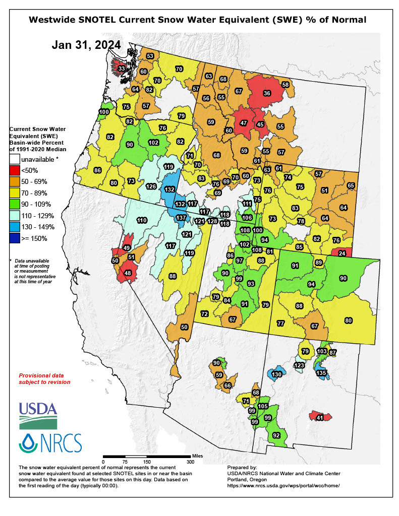
The recent rain and warm temperatures have reduced our snowpack (map above) for much of the West Cascades snowpack. The snowpack is close to 53% of normal in the north to 75% in the south. However, the Central and North parts of the East Cascades have fared better with 70 to 80% of normal.

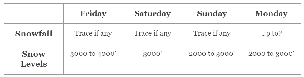
During the day on Thursday, snow levels will slowly lower and by Friday levels are close to 4000 feet. For Friday and early Saturday, we are expecting light snow. Here is the cumulative total for Friday into early Saturday: Stevens Pass is expecting 4 inches and Snoqualmie Pass is close to 2 inches for the higher slopes.


Then for later on Saturday and into early Sunday, the best chances of snow will be for the inland areas and Silver Mountain should get up to 4 inches.

Extended

The graph below shows conditions at 4000 feet just east of Snoqualmie Pass and will bring us cool temperatures for the week starting Sunday, February 4. However sadly very limited precipitation for the upcoming week for much of the West Cascades.


There is some good news for the East Cascades. For later on Monday, February 5, and into Tuesday we are expecting snow of 2 to 4 inches for mainly the East Cascades (map below). Thus areas like White Pass and Mission Ridge will do the best for those days. Although it will be breezy at times for much of the region.

Very Extended From Phil

This Friday is Groundhog Day when Punxsutawney Phil at 7:28 am EST in Pennsylvania will briefly wake up and see what the weather looks like. According to legend if he sees his shadow he will go back into hibernation and there will be 6 more weeks of winter. If he doesn't see his shadow we can expect warmer temperatures.


Is this accurate? NOAA did a study and looked at a 10-year period and indicated Phil was accurate only 40% of the time.


We will update you with this Sunday to let you know what the other extended models indicate.

Late send due to a technical issue with our email sending service. Hoping it was just a Feb 1st issue related to the new email rules from Google and Yahoo.

We're sending from new account Info@powderpoobah

Thanks,

Meteorologist Michael Fagin.


Watch for travel updates from the Powder Poobah.

Click here for the next Zoom on February 13.


CLICK HERE TO SEND IN YOUR WEATHER QUESTIONS