


Hello skiers and snowboarders,
New snow will fall in the Cascades on Friday, as a modest weather system moves in with a snow level at 4,500, falling to 3,000 ft by later in the day. The new snow will improve in quality as the snow level drops. New snow Friday will be in the 1-5” range – not a lot, but a refresh on the upper slopes.
High pressure noses in for Saturday and we will see a break with partly sunny skies. Sunday, the tail end of a weak storm moves in with light, but quality snowfall (1-7”, SL:2,000). Deepest: The Summit, Stevens, Baker and Whistler. Yes, things are starting to look a lot like Christmas.
The long-promised, late December Cascade snowfall rally begins Christmas Day.
The details in the early part of this storm cycle are beginning to come into focus. Yes, it looks like several storms are in the line-up for Christmas week. Timing of each storm, duration and snow levels remain a little fuzzy (details to come on this Sunday’s update). We will see respectable new snowfall in the Cascades from Christmas Day and beyond. The only issue I see is snow level later in the week. The levels will bounce around a bit from 3,000 to 5,000 ft. Expect occasional rain- snow mix on the lower slopes later in this multi-storm cycle.
- Christmas Day Monday and Tuesday, the snow level will be on the low side for a change: 2,000 - 3,000 ft. A White Christmas on the slopes.
- Expect 48hr snowfall (Mon-Tue) to be: 5-10” or more. That is a good trend.
- Take advantage, because nothing guarantees the snowy pattern will continue.
- In fact, the latest modeling shows a brief break with the storm track lifting into Whistler and BC, later Tuesday and Wednesday, and then later in the week aiming again in our direction.
- Too early to be confident in that outcome.
- This NW winter will be occasionally plagued by warm and dry spells with El Niño and other factors.
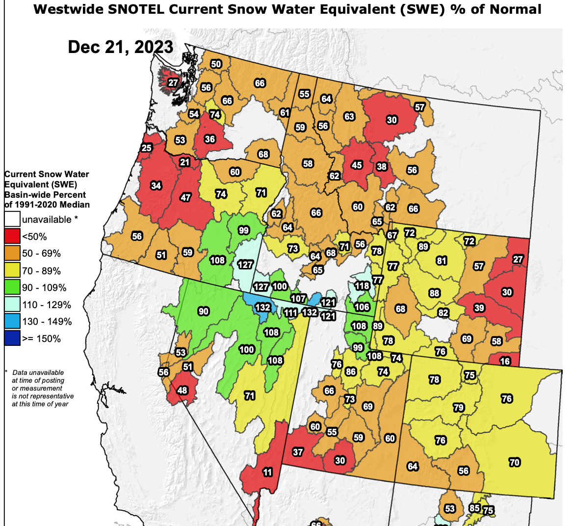
See the current snowpack map. The NW, like most areas in the West have a snowpack below normal. The ski areas are making the best of it with precise snowmaking and good grooming. But watch for thin spots. The snowpack measurement in use is (SWE, pronounced “swee”) – snow water equivalent is the water content in the snowpack. Important for water management prediction in the spring when snow melts. It’s not depth of the snow – but it’s a fair proxy for skier snowpack coverage.
Remember, most skier areas are open. Be aware of limited terrain and early season conditions.
.......................
A recent review from Powder Alert skier Sean Harvey.
Mon, Dec 18, 2023 – Lift skiing at Mt Baker
Mt Baker lift area has a decent amount of coverage. It is thin in places and there are some dirt spots but for the most part, I was able to do enjoyable runs without fear of gouging my skis.
..............................
Happy Holidays
Grand Poobah of Powder
larry schick – meteorologist
By the way...
NWAC - Check the updates to the NWAC Avy App at this blog post.


