Hello skiers and snowboarders,
Let the new snowfall begin.
Expect a roller coaster of weather ahead. There will be new snow for sure - then a rain/snow mix, with snow levels rising. The wild weather will be with us for at least a week and the result will be,initially, abundant new snow in the mountains. But it's not a clean deal with the warmth by Sunday and Monday degrading the new snow.
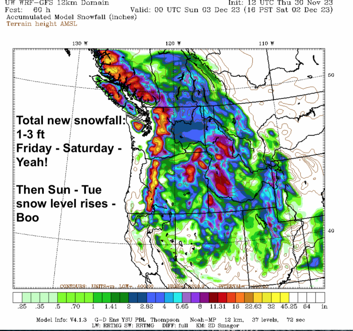
The active weather pattern I promised, is starting to take shape. Expect several storms for the next seven days. There will be one to three feet,
of new snow (Stevens deepest). Here is how the snow pattern will play out.
- Cool westerly flow will bring in a weak storm tonight with snow levels 2000-3000ft - maybe 2-4", not much. It's a wimpy, quick mover.
- On its heels, by early Friday another stronger storm moves in with additional snow (SL- 2000-3,000) with 7-17" of new snow through Friday night.
- Expect more storminess on Saturday with additional new snow 5-15" (SL 3,000).
All is good so far, right? Ok, are you sitting down? Here comes the but...
Then the incoming airflow shifts more from cool westerly to milder southwesterly direction, early on Sunday. That will bring in warmth and wetness from an atmospheric river. It means much more precipitation with snow levels rising on Sunday and Monday (5,000 -7,000 ft) to the mid and upper slopes. The previous new snow on the mid and lower slopes gets beat up with rain / snow mix and the dreaded rain on snow. The mild pattern will melt some of the new low elevation snowpack, it will not be pretty. Upper slope elevations may continue to accumulate snow or at least remain steady, with a mild beating.
Unsettled weather with more rain on snow (SL 7,000 ft) will continue on Tuesday with a healthy atmospheric river which might stall. Then in the middle of next week will see the snow levels edge down a bit to 5,000 with more snow than rain on the mid and upper slopes, but rain on the lower slopes.
I'll have an update this Sunday, considering the rising snow levels.
We'll track the actual snowfall, plus update the forecast for next week's weather. In addition an explanation of what really happens to the snowpack when rain falls on snow? As a skier and hydrometeorologist, I have researched the poorly understood impacts of rain on snow for decades - it's complicated and surprising. It takes a lot of rain to melt snow. Wind helps.
I am happy there is abundant new snow falling early in this series of storms. However, the high snow levels later in the weekend are very frustrating and will play havoc with our new snowpack. It will be especially rough on the lower ski slopes, where the snowpack is shallow.
NOTE: Some ski areas may partially open, with limited operations on certain days. Please check their websites. The early season shallow snowpack/snowmaking combined with changing weather and snow levels will be difficult. Some areas may open and close. Ski terrain and lifts will change at times. Be careful of early season conditions, thin spots, rocks, bushes, sloppy snow etc.
Please support our sponsors in your Holiday plans and gifts.
Carry on...
His Excellency, The Exalted: Grand Poobah of Powder -- Aka Dear Leader
larry schick - meteorologist
On Wed, Dec 6th I'll be doing a Zoom presentation and can take your questions in advance. Scroll down to submit your question or watch and ask live.