ZOOM WITH LARRY – December 06, 2023
YouTube recording of Zoom with Larry
We'll talk weather. We'll talk skiing, anything you want, and I'll answer your questions, of course. Some of them may be answered just with my little short program here.
Welcome everybody to a kind of rough start to the season so far.
Again, we want to thank you and welcome you, but also remember to support our sponsors too, especially in the holiday seasons. You know, if you're buying something or that sort of thing, be great to give it some help to our sponsors. They really make this happen and keep it free for everybody.
So we're going to chase the Northwest snow this winter and check out the weather for 2023, 24. I'm going to give you some insight into the extended forecast. You've heard it's an El Nino.
We're going to talk about the recent weather, which has been kind of crazy. And of course the season as it unfolds and some of the unique things about ski in the Northwest and answer some of the questions that you've already submitted. Let's take a look first from yesterday, (Dec 5, 2023) this atmospheric river formerly known as the Pineapple Express. Actually, atmospheric rivers are these thin, narrow bands of warm moist air from the tropics and subtropics that come into the mid-latitudes.
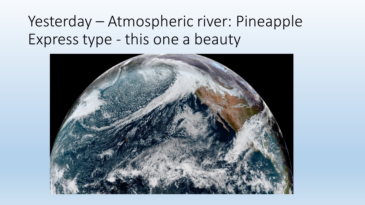
So they're not only in the West Coast, but they're all over the world, both North and Southern hemispheres. We were kind of the first ones here in the West Coast to sort of identify these as big weather makers. They're called atmospheric rivers across the world, but our particular types are called Pineapple Expresses because they come off Hawaii.
Oftentimes, if they don't come off Hawaii, then we may not just call them Pineapple Express, just an Atmospheric River (AR). But this one was a beauty. Check it out.
Now I'm going to show you my cursor. What, what the anatomy of one of these, this is the low here, a low pressure. Can you see, it's kind of curled up like a cinnamon roll.
And so what's going on with this lower pressure in the middle of this is drawing this cold air. This is what we really want is this cold, moist air here, but the real moisture is right in here and the heavy rain we had yesterday, but unfortunately this is also warm. So, you got warm and moist here and you got kind of moist and cold here.
This is the sweet spot for powder snow. So, when this tends to migrate over you, this is when we get our best powder storm. So just FYI, this is a good example of kind of the big mix.
These are far bigger than any hurricane. So don't be impressed with your East Coast friends when they're bragging about the hurricane. These things are, look at how huge this storm tails back way across the Pacific.
In fact, some of the origins are back in off Japan and the whole Hawaii. All right. Enough of that.
Let's recap what happened the last few days. Cause it was ugly. We started in with kind of a below normal snowpack over the weekend.
We did have some fresh snow, but it's been below normal. And then we really got beat up, you know, Monday and Tuesday with the warm air and the rainfall. And we had the floods of course, too.
Remember, here's another thing I hear on TV constantly. People were saying the snow is melting, causing the flood. That does not cause the flood, by the way, only about 10 to 20% of the runoff in those rivers is from snow melt.
So snow melt does not cause the floods. The flood is caused by heavy rain and the rain, as you know, was like four to eight inches of rain. That's where the flood was coming from.
There's a little bit of contribution from snow melt, but it's really exaggerated. Most people don't understand that. Snows were 8,000 ft plus yesterday.
Oh, oh, that hurt. But the last part of the snow storm or the rainstorm, the snow did start to fall later last night and this morning. And so that was good news.
And that's typically what happens with these Pineapple Express patterns. It's warm. And then the tail end of it, the snow level lowers as the colder air moves in.
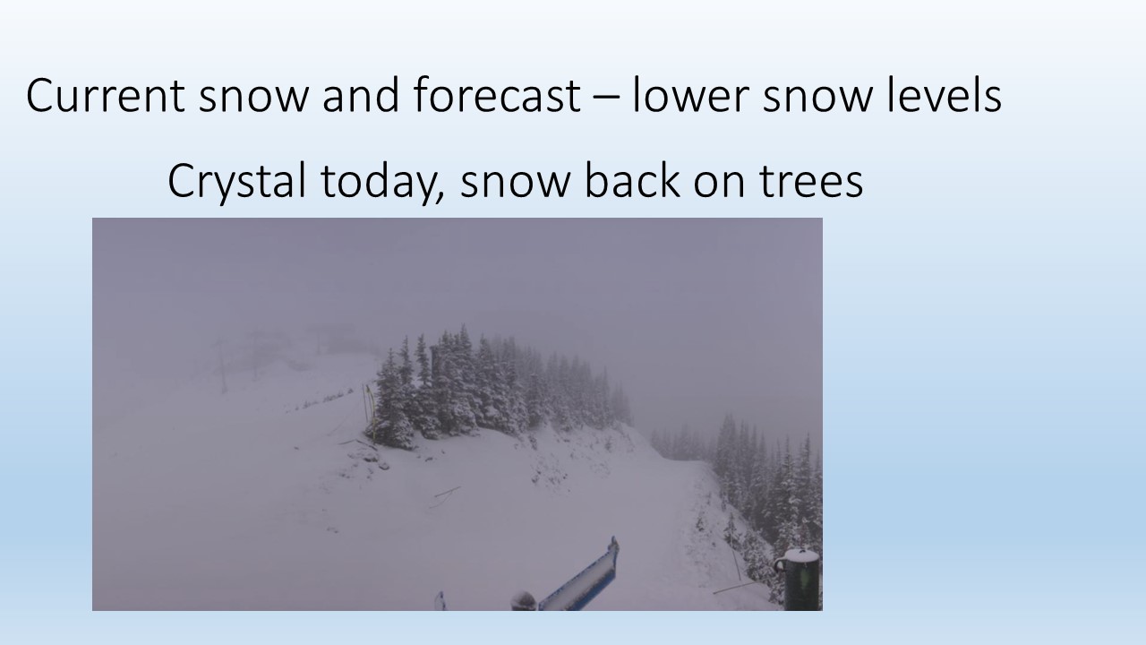
So this is a picture from Crystal's camera this morning. You can see these trees did not have any snow on them yesterday, but they were starting to pick up some snow this morning. So we did get the lower snow levels.
The snow is back on the trees. So that did help the situation in the mountains for sure. And we didn't lose the whole snowpack.
Don't get me wrong. We lost some of it, but it didn't disappear. So that was an exaggeration too.
A lot of forecasters are saying on TV, we're going to lose all the snowpack. No, no, no, no. It takes a lot of rain to melt snow a lot, like five inches to melt like a foot of snow, maybe up to eight inches.
So it takes a lot. So yes, it melts, but not as much as most people think. Okay.
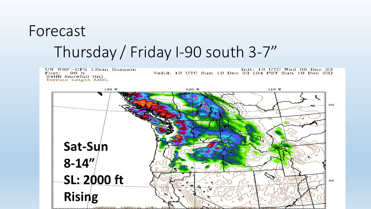
For tomorrow, Thursday (12/7/23), and Friday (12/8/23), the storm is mainly going to hit South of I-90, 3” TO 7” inches, but the bigger storm with lower snow levels is going to be Saturday into early Sunday, 8” to 14”. So, all right, we've got redemption coming up in the next couple of days. So that's a good forecast there coming up for the weekend.
We're going to get some of the snow back. It won't totally open everything up, but it will be improved. And so, you know, once this stuff gets buried, by new snow, it's down there really nicely coating the rocks.
In some ways it's kind of good to have a real wet sloppy base, it freezes, and then we get real snow on top of it. I call it real snow because it's, you know, skiable. All right.
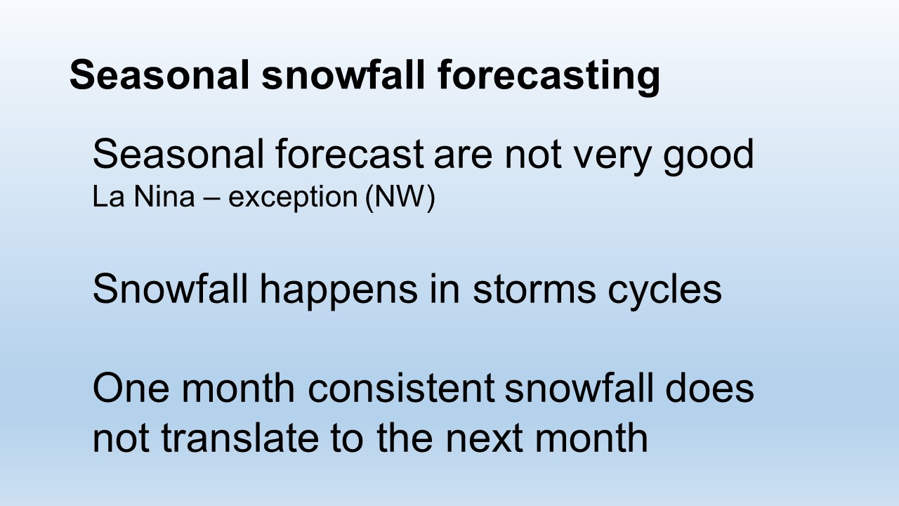
Here are a couple of notes before we really get into the seasonal forecast, because these are, these are different than the short range forecast. The seasonal forecast, which means El Nino and what's going to happen the next few months. They're not very good.
I think the one exception is during La Nina, which is last year. The Northwest is pretty predictable in having good snowfall during La Nina. So what I mean is that generally means cool and at or above normal snowpack.
So that's the exception, but these seasonal forecasts are all over the map. Here's another thing. Snowfall happens in cycles.
It happens over a few days or maybe a week to 10 days, and it just dumps like crazy or it's a dry pattern. And then it recycles around into something else. So it happens in cycles.
You got to jump on these cycles. That's what's critical. And here's another thing.
Some people go, “oh, it's been snowing all month. It'll be great next month. No, no, no, no.”
It does not translate to the next month and vice versa to remember. If we get a dry spell of a few weeks, it doesn't mean the rest of the winter is dry. It does not translate to the next month.
Weather does not remember what happened a month ago. All right. We got that.
All right. We'll share a few questions here. We'll have some more information here in a moment.
QUESTIONS…
I'm buying a cabin. in the next 20 years where would you buy the cabin?
Which mountain, considering the fluctuations with global warming, that sort of thing? So, here's what's going to happen with global warming.
We're not very clear on what's going to happen with precipitation. In fact, in some ways, there might be more precipitation in the winter. But we do know pretty confidently the temperatures will warm up.
They'll edge up slightly. Overall, in the next 20 to 30 years, snow level on average will go up about 1,000 feet. It's probably gone up a little bit on the average already.
But remember, each year from year to year, it fluctuates greatly. You can have colder years and then warmer years. There'll just be more of those warmer years with less snowfall in the lower elevation.
So where would I build a cabin or where would I have a cabin? I'd go highest you can in the mountain. Whatever mountain you like that's the highest elevation and the farthest north. So maybe somewhere in northern British Columbia on a real high mountain.
That would be the exaggerated answer. But that's the idea. You want to get the elevation and you want to go north.
A question about Colorado or Utah this winter.
You'll see in the forecast here, it could kind of go either way. They're leaning a little bit on the above precipitation side right now, the latest.
But my philosophy is just go. What are you waiting for?
Avalanche issues. That was mainly a question last week when we had that kind of dry spell and some hard packed snow.
What would happen with the rest of the winter with snow on top of that? That's kind of dissipated now with all the rain that's gone through the snowpack. Here's the thing about avalanches. When you hear the avalanche warning, you should always be aware any time skiing.
I've been caught in an avalanche inbounds in a ski area. So it can happen inbounds and it was under no avalanche warning or watch. It was a shallow one, but nevertheless, it took me down about 30 yards.
It was only about maybe two to three feet deep. So it can happen. But here's what you should know, and I should have known better too.
It was snowing like one to two inches per hour. Duh. So it's piling up like crazy and I just got caught in a slough.
And anyway, just be avalanche aware. When the weather changes, snows a lot, rains on snow a lot, any kind of radical change in temperature or precipitation, then the avalanche issue should be first in your mind. Again, these avalanche warnings do not count in ski areas or roadways.
They have their own avalanche management and mitigation. But you should still, if there's an avalanche warning, you should still be aware. There's still an enhanced risk.
Global warming in El Nino, what's going to happen?
Not really clear on that. What a lot of scientists are saying, and it's not really clear, is that El Ninos might become stronger because there are warmer ocean temperatures. But this fluctuation between drier weather, because remember, global warming also means dry weather and more evaporation and higher snow levels.
But it also means more moisture. So, there are a lot of complex moving parts to this. And I don't think the scientists settled at all with that, with global warming in El Nino.
In fact, as you're going to see in my talk here, it's not even that settled with El Nino.
Should I buy a pass this year?
Well, a lot of the passes now, some of the big corporate passes, the date has gone by, but there's still some available. In my opinion, I'd always buy a pass, because if you want to get stuck, it's really good, and you can't go.
I mean, last year was a perfect example, La Nina, California is expected to be dry. They were in a dry spell, dry, dry, dry, dry. And people that didn't buy passes down there got burned and got wasted out of one of the best seasons ever.
So, you know, buy a pass. That's my philosophy. And just, you know, lick your wounds if it doesn't work out.
Best snow apps
I think OpenSnow is good, but it's a paid app. I think the Weather Channel has really good apps and a really good situation as far as getting weather information. So, I like them, too, and they're free.
Where do you go to find good powder?
Well, you know, it really is snow-dependent, obviously, but I mean, storm-dependent, it really is. What I always like to do is follow the storm. Okay, so the first part of the storm, it can be dumpy pretty good, but I like the second half of the storm, because the snow levels tend to come down, things kind of ease up, the winds ease up, that sort of thing.
So, find a storm or a storm cycle and then jump on it. That's where to find good powder.
Where do you find a good mountain?
Well, it's the mountain that you know best.
You've got to have a mountain with enough vertical because once you get powder, as you know, you need a slope that's a little steeper than your normal slope because that snow really slows you down. So, I like a lot of vertical. The best would be 2,000 unchecked continuous vertical with a foot and a half of new powder snow.
There you go. There are not too many mountains that can do that. Crystal's one, Whistler can do it, Jackson Hole can do it, Grand Target can do it, Snowbird can do it.
But, you know, you can do plenty of good runs, 1,000 vertical. I've skied fantastic powder runs over at Silver Fir at the Summit at Snoqualmie, but the snow was perfect. That's the key.
You get there early, and you jump on it. You have to know your mountain, know your geography, know your ski area, and know the weather. Watch those snow levels.
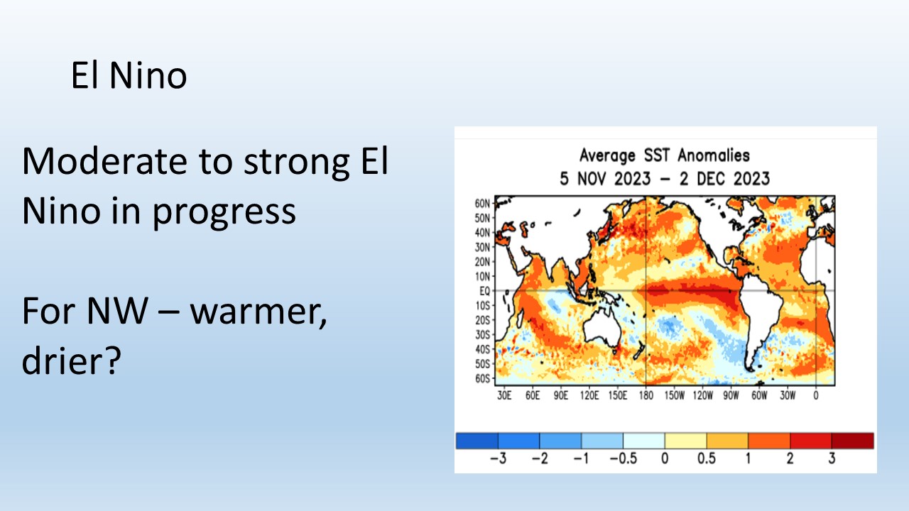
Let's talk a little bit about El Niño because this is the big El Niño year. Right now, we're in a moderate to strong El Niño.
It's in progress. For the northwest, it's going to kind of lean warmer and possibly drier. Now, if you look to that graphic to the right, this big red area down in the equatorial Pacific, that's El Niño.
It's warmer than normal area out here. And you ask, how can that affect us? And there are warm areas out here, but, again, they're relatively warmer than the normal cold North Pacific. This is the relatively warm equatorial region.
So this is temperature, I think it's Celsius, above normal. So that's what the numbers you're looking at here. So you can see most of the oceans of the world are warmer than normal.
It's a little bit off South America here. But everybody's really doing quite warm. This might be a reflection of global warming.
So, how this can affect us? What happens is it creates thunderstorms down in these areas that normally don't exist. And the thunderstorms bring up this warm air really high in the tropical Pacific. And that creates a ripple effect all the way north to the North Pacific.
It adjusts the storm track, which normally kind of cuts across here. And it'll make it cut farther to the south, or there'll be a split storm track. And that's how it all works.
So, in a sense, we're not directly involved with El Niño, but it changes the circulation in the upper atmosphere. That's how El Niño works. And it's very complicated because it's just not cut and dry.
Okay, there it is, we do this. There's a lot of background stuff. They all start on different background antecedent conditions in the ocean and the atmosphere.
So that's why sometimes it doesn't work out. It's not a slam dunk. Do not bet on El Niño.
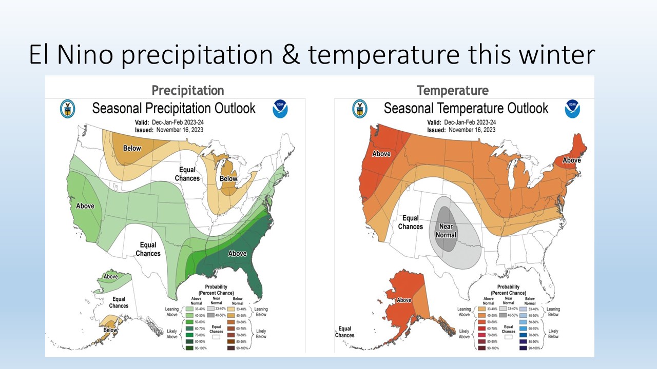
But here's the forecast, because there is huge demand for the extended forecast. And this is from the Climate Prediction Center for December, January, and February. Remember, El Niño’s effects don't typically start until late December into January and February.
And what it shows for that period is the northwest sort of equal chances of precipitation. Could be above, could be below. So, they're not committal on that.
A little bit below up into the north. But again, remember that you don't know when that below is going to occur. If it's going to occur at all, is it going to be front-loaded into the first part of the season or back-loaded in the back part? You don't know.
Same with down here to the south. Will it be a dud in the first part of the season and gangbusters second or vice versa or not at all? So just be aware of that. That's the uncertainty we're talking about.
Now, the temperature we're a little more confident in, this will mean some higher snow levels. Not all the time, not every storm, but some higher snow levels, you can see. And they were talking, somebody was talking about Colorado and Utah.
You can see near normal temperatures there and kind of above normal precip. But you know what? Two months ago, it wasn't showing this at all. So, things change.
This gets updated every 30 days. So we'll see how it goes. But this is kind of the classic El Niño pattern, wet in California and drier than normal in the northwest.
But it's not saying drier than normal. It's just saying near normals. Again, don't take this to the bank.
Don't get married to it. Go skiing when it's good and it will be good. All right, so it's peaking right now.
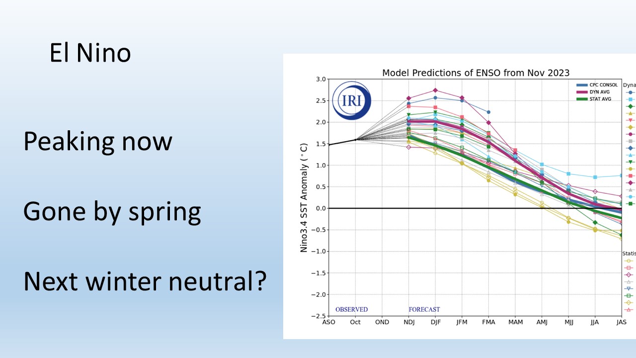
Here's kind of the forecast. This is called an Ensemble Forecast. It's different models giving different forecasts.
And we kind of generally try to stay in the middle of it. But it could go as high as a really strong El Niño, or it could start backing off really quick. But we usually take the middle of the road here.
And so it stays El Niño here, but it starts to drop off by late winter. And then it kind of switches to neutral by summer, and next year it kind of goes toward neutral.
Again, this changes like every few weeks too. So be aware of that. Things change.
We change these forecasts all the time just to keep you on your toes. But anyway, next winter could be neutral. All right, here are some of the effects worldwide.
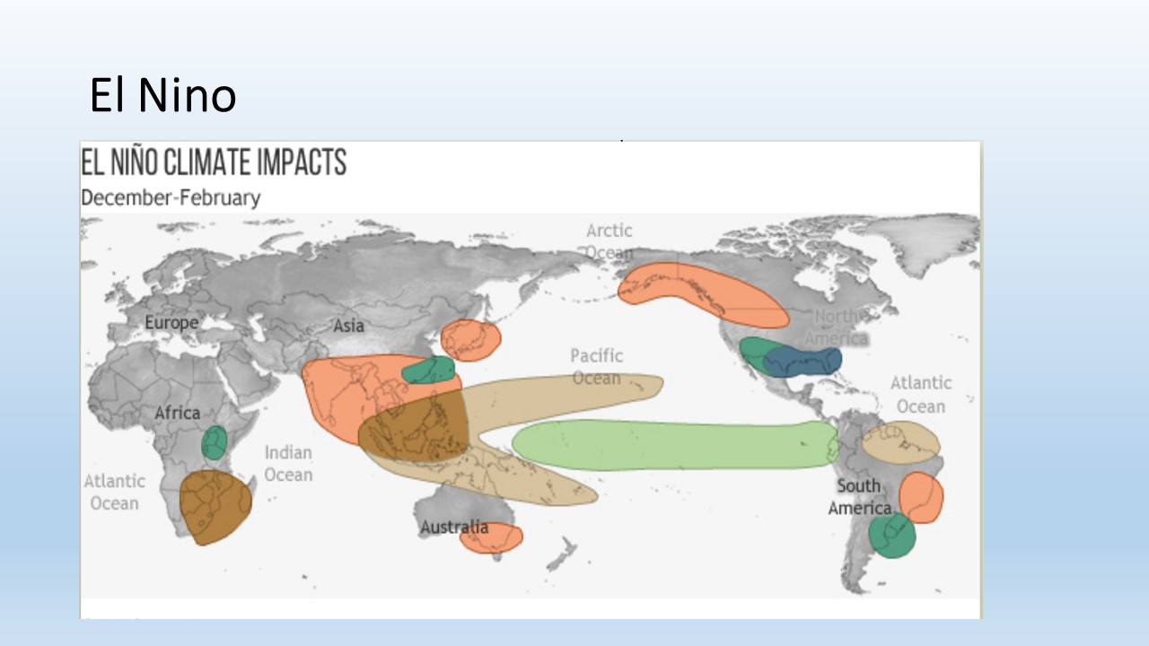
A lot of people think, oh, something's going on. You know, you've heard about all the snow in Europe, right? They have no El Niño connection. Come on.
So that's just a normal pattern they're having, but they're having some early – really good early snow in the Alps and parts of Europe. So be aware of that. There's a lot of patterns down here in the tropics because, remember, El Niño is happening right along here.
And so when you're close to it, you get more effects. Australia gets really affected by it, parts of Southeast Asia. But even in the eastern part of the country, no El Niño connection.
Parts of South America, not all, no El Niño connection. So just be aware of that. Now, La Nina, a different story.
But, again, for us, it's going to be kind of warmer than normal, but also that precip kind of extends into parts of California too. But, parts of southern California or Arizona or southern Utah, southern Colorado, like Brian Head and – what's that? – Telluride, they'll be – they might – they could benefit real good. So watch places like that if you can move quickly.
You know, Taos can sometimes do really well in an El Niño too. But, you know, don't be afraid. Our neck of the woods is going to be fine.
The northwest rarely has a dud. Okay, we've had a couple of duds, 2015 and also 2005. Those were bad years; I have to admit.
But, you know, even El Niño, it doesn't matter. We have good years consistently.
Here's what it looks like over the years if you're wondering.
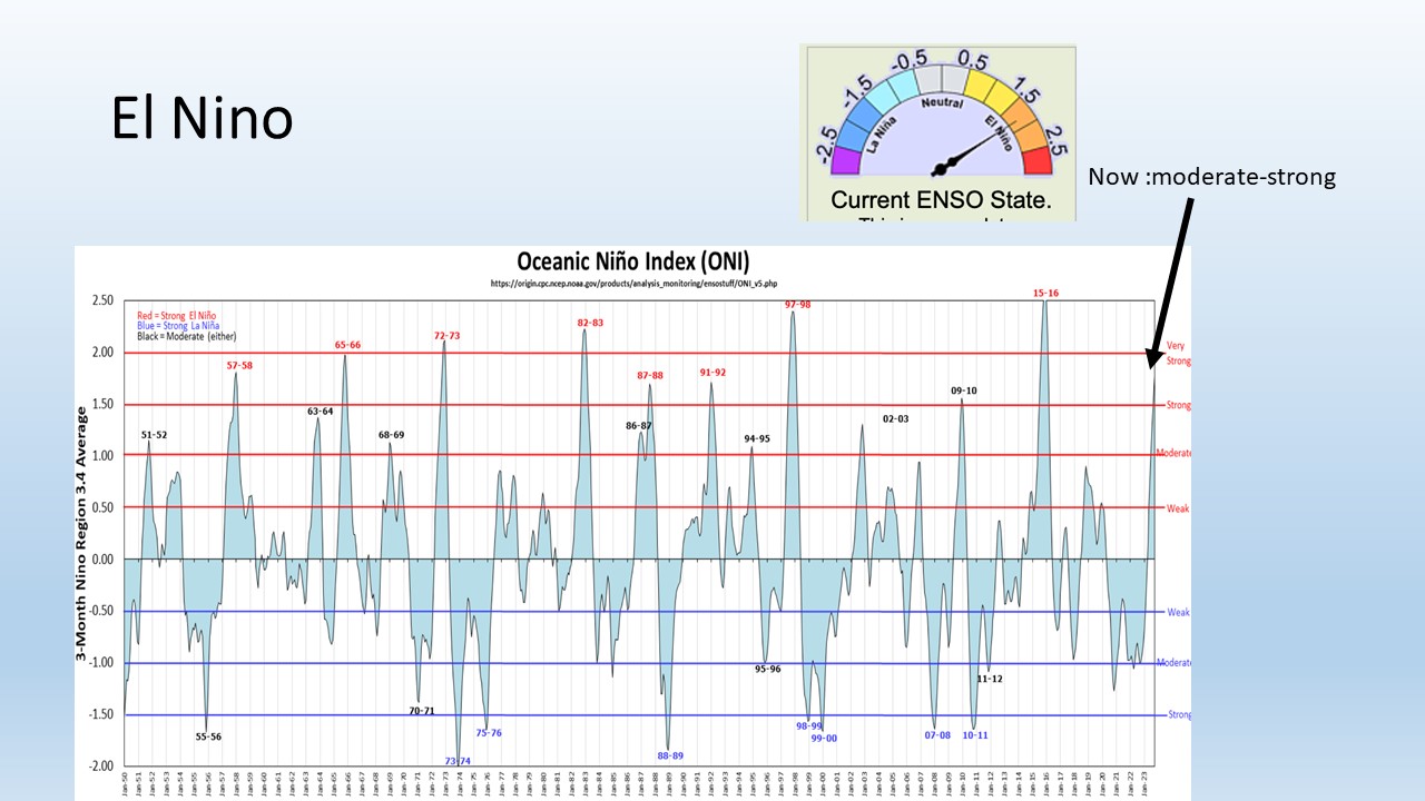
All right, the central line is sort of neutral. Slightly above is still neutral, and slightly below is still neutral. Anything above this red line is El Niño.
Below this blue line is La Niña. We're right here, so we're pretty strong. La Niña, here's the last one, 2015-16.
That was not a good year for us. 2005 was somewhere in here. So it wasn't that strong, but that was a dog year too.
Okay, this one I want to point out. Right here was La Niña. This was the record snowfall in a lot of Washington, the world's record in Mount Baker.
It was right around here. But we've had stronger La Niñas, so it's not necessarily proportional. But that record for, what was it, 1,140 inches at Mount Baker, that was right in this area right here, this La Niña.
Oh, I'm sorry, I got it wrong, sorry. It's right here. That's where it was.
Sorry about that. So it was right in here. So that was a pretty good La Nina.
I had that wrong, sorry. So interesting, it was followed by this really strong El Niño in 1997-1998. We kind of got hurt a little bit, but boy, we got the goods the following year, in 1998-1999.
That's when Baker hit that record of over 1,100 inches, really. So you can see how it goes. You can see how it fluctuates back and forth.
Some are strong, some are not so strong. It goes back and forth. What actually happens is the water in the ocean, interestingly enough, in the Central Pacific, I should say, the tropical Pacific, it sloshes back and forth like a bathtub, you know? When you jump in a bathtub and it sloshes one way or the other, that's what happened over a year or two or sometimes up to a five- or seven-year cycle that cycles through it.
I want to touch base with you about the CONVERGENCE ZONE.
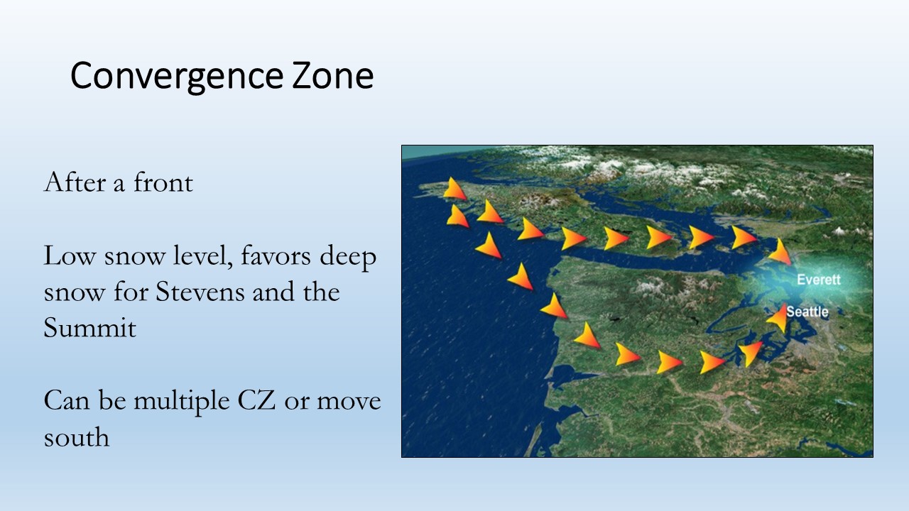
We hear a lot about this. This is typically after a weather front goes through, the air following the front comes in from the west and northwest.
It hits the Olympic mountain range like a boulder in a stream, and that cuts the air to the south and to the north, and then it rejoins right around Everett, and it produces rain, Everett, and then snow in the central Cascades, mainly in Stevens. So that's the classic version, but here's a couple things. I've seen multiple versions that hit Mount Baker or Crystal and bypass Everett.
I've seen them migrate down. That's not unusual, or deform there, and then it migrates south as the wind shifts in the summit, and Crystal really gets it, and White Pass gets it. So, watch for those things because they will enhance the snow quite a bit.
You folks that ski Stevens a lot, you know it pounds there sometimes. So it does favor that in the summit, but it doesn't disfavor necessarily other places. And here's another thing. The snow level is always low when this hits because it's after the front.
This is the weather pattern. It hits after the front moves through. So it's usually the hours or a day after the front you get this huge convergence zone.
So be aware of that. It's a kind of unique feature that we have here in the northwest, and so it can really mean enhanced snowfall. And those odd ski powder days at Stevens that were unbelievable in those convergence zones.
I mean, it was dumping an inch or two an hour, and I've seen it more too. So it fills in your tracks. It's hard to see, actually, but the snow is really good.
Anyway, that's it for the convergence zone.
Here's what it looks like on the radar. It kind of extends.

It's kind of a cigar-shaped moisture band. Usually, it doesn't kick this far north. Usually, it's a little bit more flat, but it takes all sorts of different forms.
But just watch for that for sure. And that's kind of a look at some questions and answers and also some things about the northwest weather.
QUESTIONS…
Can you please define the term atmospheric river and how it impacts snow level and ski conditions on the slopes?
Okay. We went through that a little bit, but we'll just do a recap.
Here's a classic one yesterday (12/5/23). The atmospheric river is a narrow area of water vapor. It's actually water vapor in the lower atmosphere.

It's in the lower 10,000 feet of the atmosphere, kind of ahead of this cold front here. And it could be 1,000-plus miles long and maybe 200 miles wide. And when it hits the mountains, it really squeezes the moisture.
Now, this storm, as it wraps up, it draws warm air from the south, and so that's why the snow levels go up. Typically, they go up, you know, above 5,000 - 6,000 feet, and they stay there for maybe 12 to 48 hours, depending on the size and the movement of it. And, yeah, it's a mess when they happen.
There's no question about it. But like I said, the good news is they do dissipate and move south, and then you get the cold air, and that's what we're getting right now. And so it tends to, after it destroys part of the snowpack, it tends to put new snow on a nice veneer.
But that's the Pineapple Express atmospheric river.
From Bob, he wants to know about snow forecasts this season for the French Alps, Chamonix, Courchevel, and Val d'Isere.
Well, the only thing that we have is the El Niño forecast, and it doesn't affect Europe, so we really have nothing to base a long-range forecast on. And that's true of most places. And the only thing I can tell you is they've got some early season snow, which is good.
At least they'll have something. Who knows? I mean, nobody knows. You know, this is all theater that people pretend like they know. Nobody knows.
(Andrea) Yep. Nobody knows. A couple years ago, I skied Taos Ski Valley. You said, we don't know what it's going to be. You were right, we had two days of new snow, and that was in March.
AlpenPaul is going to go to Tahoe, and New Mexico.
Okay, here's the deal, folks. I know everybody wants these precise long-range forecasts, but they do not exist.
And so here's what you do. You just plan your trip. You have two options.
You plan your trip and go. Or if you can wait until you see these short-range forecasts, you can do that. You can follow them and get the storm you want, but you can't do it with a long-range forecast.
It's too vague, and there's no way you can do it. There's no way, N-O way you can do it. So it's kind of meaningless, in my opinion.
But you can do it if you can be flexible, and you don't care about a $2,000 ticket to Europe. You can leave at the last second and nail whatever storm you want. The short-range forecasts are really good.
I mean, I would bank on that, but the short-range cost is exorbitant. That's the reality, I have to tell you. That's the reality.
Liz wants to know, how would you characterize the difference between the Canadian Okanagan and West Coast, like Whistler, for instance?
That's a really good question. So, if everybody doesn't know, the Okanagan is just over the coastal range. It's sort of north of kind of central-eastern Washington.
That's where the Okanagan is in British Columbia. And it is just east of Whistler, but it's over the coastal range. So, the difference can be quite dramatic.
I've skied them both there in those interior places. First of all, the Okanagan doesn't get as much snow as the coastal areas like Whistler. So that's one thing.
But the good news is that snow tends to be better because it's colder, and there tends to be more sunny days, or at least not as much fog. The problem with Whistler is fog, in my opinion. The problem in the Okanagan is there's not as much snow.
So sometimes you get hurt by that. But it can be cold and dry snow, and when it's good, it's good over there. It is drier snow, no question about it.
There are less crowds. It's more than a weekend trip, in my opinion, to get to some of those places because instead of a 4.5 or 4.15 drive to Whistler, it's a 6-hour drive to what? Sun Peaks or one of those places. So it's a haul.
But that's the big difference. Not quite as much snow, but when they get the snow, it's good. I mean, Sun Peaks is fantastic.
I've skied there under perfect cold conditions, but really cold, 5 below. It's not always that cold, but it is colder than the western places, you know, Whistler and stuff. But the tradeoff is Whistler, you get plagued by that fog, and it can be not fun.
Paul wants to know, with climate change, do we need to think about streams below the snowpack?
I meant streams. Do we need to worry with global warming? Yeah, streams. I meant that the streams you sometimes in the spring, it's easy to fall through them, and I've noticed them more higher in the mountains recently.
Oh, I see that. I see. Well, gosh, you know, probably.
But I think any time, any year that can be dangerous, it kind of partially is all about what happens in the spring, and that might be a little warmer as well. So, yeah, I mean, I would always worry about that, you know, any time I'm skiing in the spring, something collapsing. So I don't know if we need to worry about it more.
I think there's bigger fish on the plate to worry about than that one. Yeah, I think so. But I've never seen any research about that.
Matt wants to know about, can we hear from Larry Schick, weather singer? Oh, that's pretty good. That's a throwback to like the late 80s when I was on King TV and King radio, and we had this singing weather.
They'd sing the forecast. It would take about 10 seconds. One of them would go, “It's going to rain, drip, drip, drip, drip, drip.” Boy, that's really, somebody was paying attention.
That's 40 years ago or more. Jeez. Thank you, Matt.
Brendan wants to know, what source can I look at to see where a convergence zone will hit?
So it takes a little bit of analysis to, you know, figure it out. But a couple of things. First of all, the National Weather Service has their forecast discussion.
And if you read those, they come out about once every six hours, and they'll mention the convergence zone. So they'll mention it. That'll help one thing.
You can also see them on the radar. Remember I just showed you that picture. Let's see if I can find it again.
And you'll see something that looks like this cigar-shaped band on the radar.
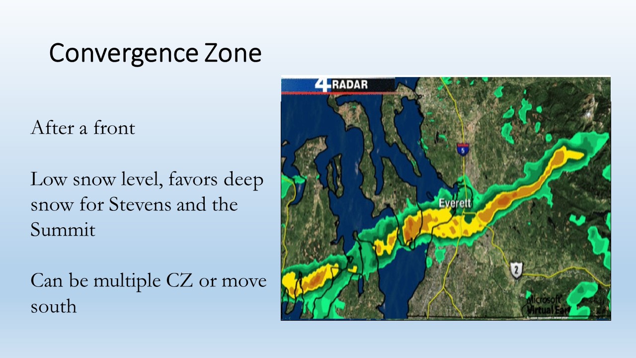
And that's, again, after a storm comes through. And then look, look, look on the pictures at like the summit, I-90, and also if it's Stevens Pass, the picture.
Is it dumping at the same time? It should be. So, you know, you use different sources to reinforce the idea once you think that's going on. Most forecasters, both on TV and National Weather Service, they're totally watch these things.
But you can watch them too. And quite frankly, you can see them on the weather maps come in, in most cases. Just the key is after a front goes through, that's when they normally show up.
And they normally show up like in the springtime a lot. You know, I do see them in the winter, of course, too, but the spring they seem to show up a lot. All right.
From David, Does the 23-24 season, does this winter season have any analog seasons in the historical record and are analog seasons a useful predictor at all?
What he is talking about is, we've got this El Niño this year and like here. And so what would be an analog year? Here'd be one here.

So something similar, a big one. Here would be another one. These would be similar years, you know, and that's one way to do an analog to see, okay, well, what do we do with other El Niño years? And you know what? Sometimes that works and sometimes it doesn't.
To tell you the truth, it does work slightly more often than not because that's why they have an El Niño forecast. They've looked at all these things upside down and see what happens. Here's the problem.
There's a lot of exceptions to what happens. And, again, like last year, if you had followed the El Niño forecast, you lived in California, it was saying total dry, bad dry, and you would have missed one of the best seasons ever in California. So, yeah, kind of, but you're taking a chance with your analogs and it's not that solid.

All El Niños and La Niñas, they start with a different set of conditions, as I told you, different set of like ocean temperatures. So we've really not seen an ocean like this warm over such a great area. It doesn't happen very often, you know.
So that's an unusual setup for what would be kind of a classic El Niño. This is no doubt a classic El Niño. Anybody that knows anything about weather or El Niño would look at that and go, hey, it's El Niño for sure, and that's a pretty strong one.
So, yes, those analogs, they're there. You can find them. But here's my contention.
I don't know. Maybe I'm a crazy guy, but I'm like, okay, we have El Niño. It gives us a little hint of maybe a nudging.
Am I going to make a serious decision about my life based on that? Hell no. I'm going skiing, you know. So, I mean, you know, why would you do that? There's too much unreliability.
It's not like, you know, paying taxes. You've got to do it, right? It's very unreliable. I think part of it's been oversold by the scientific community and others, but it has some great predictive value, but it's not that great.
I'm not saying it's zero, and I think it's the best we got. So, there's some value in it, but I would challenge anybody to say, really, would you make a decision off that? No, I wouldn't. So, I mean, if your last dollar is to buy some bread or a ski ticket and you're looking at El Nino, I guess I would.
But in most cases, I wouldn't make a personal. When I worked for the Corps of Engineers, here's an example, folks. When I worked for the Corps of Engineers, we had flood control, all this really serious stuff.
If we made a mistake. It was bad news. And so, we couldn't afford to take a chance.
And so, I talked to these Climate Prediction Center weather people for endless hours because I wanted more information for what the winter was going on, and they really couldn't give me anything solid. You know, they did the best they can, but that's the best we got. So, we couldn't make a solid decision on flood control or something like that with that kind of unreliability.
But that was a severe example because, you know, it was life and death, really. But it was just a ski pass, I think. So, I'm going to live with it.
What about a Mission Ridge prediction for KJR?
So, Mission Ridge kind of fits into this drier and warmer part.
The good thing about Mission Ridge, in my opinion, is they have really good snowmaking. They're already skiing, I think, top to bottom. So, they've got good snowmaking.
They often have cold enough temperatures, so they're not as vulnerable as we are to the warmth. I think they're more vulnerable to the dryness part of the equation. So, just be aware of that.
But I like Mission Ridge. You know, go for it. Especially, here's a Mission Ridge tip.
If you ever see a low-pressure kind of going from the Columbia River mouth, which is just to the west of Portland, and kind of migrating toward, like, Mount Hood, that is a perfect circulation pattern for Mission Ridge. You'll get what's called this wraparound upslope snow in the east slopes of the Cascades, and you can get a dump and cold snow that will be the best powder skiing of your career. So, just be aware of that.
I told you. It happens once in a while. I try to point them out when I see them, but, you know, I'm not 24-7 at your doorstep, either.
Do you have a sense of how the snow is going to be over Christmas, New Year's week?
No, I don't have any sense of it right now. I don't have any sense of what's going on. I don't have any sense of what's going on. (some portion of the transcript is missing). Essentially, 1-5 day range we have a pretty good sense of what’s going on with the weather. If you really want to chase the snow, you have to be able to pivot quickly.
Darron wants to know about the other forecaster that is working with you.
Michael Fagan, fills in and does it sometimes more than me because I'm out skiing. And he has been a snow person for a long time.
He has done these forecasts. He still runs his company where he does forecasts for climbers up on Mount Everest. So, how's that? So it's really fine tuned to specific forecasts in the Himalayas, which is beyond my expertise.
Michael has experience with mountain forecasting and that sort of thing. He wrote a book: Best Rain Shadow Hikes – Western Washington. AMAZON link.
And so these are areas in the Cascades that tend to be drier than other areas. He's familiar with Northwest weather and Northwest mountains as well.
(Andrea) I get to collaborate with Larry, post on social media, and I get to give away prizes and have parties. Watch for the contests coming up this season. We get cool stuff from our sponsors.
How's White Pass for this season?
You know, it's in the same bucket as everywhere. You know, they've got good snow coming up here in the short term. I think they'll do really well tomorrow and over the weekend. And over the season, there's no reason to believe there'll be any different from anywhere in the Cascades.
So some challenges with some higher snow levels once in a while, but I think everybody in the long run will be fine. But, you know, like I said, this El Niño, it can be wicked sometimes to us. I think that's the only thing I've seen in the past that sometimes we can have some higher snow levels.
One year, was it 2015, we had normal precipitation, but the snow level was high the whole year, almost the whole season. And so it was really a snow drought, but normal precipitation. Very strange.
I don't think that'll happen again, but I can't say that it won't. You know, we are moving into this warmer climate regime and El Niño does produce some warmth. So we'll watch for that.
You know, it could bust, but you know, it could bust any year too. And we've had bad years even before global warming was an issue.
Ed is saying, yeah, it dumps at Revelstoke, eight-hour drive, no crowds, most vertical drop in North America. And they just opened recently, a couple days ago.
Yes. Some of the interior, that's farther interior than we're talking about the Okanagan. That's kind of a North, Northeastern BC, a great spot up there.
It's beautiful. You know, that's kind of near where a lot of the heli-ski operations work out. So there's lots of snow, beautiful area, nice drive.
We're so lucky here. We can, we can drive from here to Spokane, and ski 49 Degrees North, one of our sponsors. Go up to the farther north across the border and ski Red Mountain, ski up the Powder Highway to several other spots, kicking horse, Fernie and Revelstoke. I mean, we've got it made gang. And just outside our window.
We have all these areas super close to us from Baker to Snoqualmie. You can do that after work. There are just so many great spots here.
We're lucky. I have a lot of friends that are envious, of what we have on our doorstep and then just with, a half a day's drive.
Louise, she's skied in the PNW for over 60 years. We have a ski season nearly every winter. Like Larry says, sometimes it starts later, but it nearly always starts.
Yes, that's a really good point. We're not like California where it's like can be a total dud for a year or two or just backloaded or really, it's not as volatile as that.
But, you know, we have some volatility too. I can't deny that. But you're right.
It's really rare that we don't have something. We might have to wait, might be backloaded, frontloaded, that sort of thing. But it's really rare that I think the only season I think was 1977 was the only season where really all of British Columbia, all the Western United States was bad, almost the whole season.
There was a little, little comeback late in March. But that was, that was one of the, that was considered really the worst season in the entire West because everybody, it was bad news for everybody. But that is super rare.
And that was before global warming too. So see, there are some extremes along the way here.
From Ed: If you had a week, where would you hit it on the Powder Highway?
If I had a week, first of all, I wouldn't leave until the last. It all depends how flexible again, because I don't want to be driving in the snow. I just want to have it.
I want it to be sunny during the day and snow at night and I don't want to drive it. How's that? So anyway, I mean, if I had to plan something, I think you're right. You know, some trip through part of Washington up through British Columbia and then up through that circle back around would be great.
I mean, that'd be a great week trip. You know, those places are, I mean, they're not very crowded, especially during the weekdays, you know, weekends, a little bit more busy, but I would kind of head that way. You know, you start to go to Utah and some of those places, they get pretty busy.
British Columbia is still somewhat untouched. At least if you stay away from the weekends, weekdays are really nice. And those areas are cool up there.
It's beautiful up there in the wintertime. So that's where I'd kind of go, but I'd make it part of Washington, you know, circle around to Silver Mountain over in Idaho, one of our sponsors, then head up north, head straight north from there to Fernie. That's one place I haven't been to. I've really wanted to go. But anyway, so that would be a good week trip to do. I did my week trip for, you know, headed east all the way to Jackson Hole, but I skied all the way over there last year.
But boy, I would not want to do that in a snowstorm head over there. Oh my gosh, that's a long drive. But anyway, watch the weather.
The short-term weather is the key, is the key.
There's a friend of mine called Powder Chaser Steve, if anybody's ever seen him. He's the only person I know that has skied at the best ski areas on the best powder days on the best slopes and first a chair, not once, but multiple times.
And so he's seen everything and he has his five or six best powder places. Guess what? Two of them are in Washington. They're Crystal and Stevens because of snow and because of continuous fall lines.
And that's key when you're on a snowboard. You don't want to go a thousand vertical and hit some bench. You want some continuous fall line.
And so there are only a handful of skiers that can give you that without benching out or, or cutting. And so he has skied the best skiers in the best place. Powder Chaser Steve, you can check his website.
He's a wacky dude. I mean, he'll get up and stand in the lift line two hours before he even opens. I've seen him in Crystal, like two hours before the lift even open.
He's just standing there waiting, but he'll get first chair and he'll take one or two runs and two runs at the most. And then he'll get in his car and go back to Utah, where he lives. He thinks very highly of Washington.
He loves Baker too. On a good day, he loves Baker just a little more difficult to get to for him. But he loves our snow, he makes the case and he lives in Utah. He makes the case that our snow may be a little heavier, but it's more prone to not slide like the Rocky Mountain snow.
So again, it gets plastered very well along the slopes. And he says, he thinks it's, it's better to ski the, the dense, slight more density of a fresh snowfall in the Northwest is actually better to ski than a very light powder day in Utah. That's his opinion.
And he's skied the best of the best. Of course, I'm always standing up there on the best day. So I think our best days can compete against anybody.
Sorry, light snow people, but when we have fresh snow can't be beat.
Ed asks: Any shout outs for us cross country skiers in the Methow.
It's just like the best over there. Come on. That's the best cross country skiing, on the planet, you know, you've got it to yourself.
It's the trail is so long. I mean, the snow quality, especially from now through January and February is so good. You know, it's just fantastic.
If you haven't been over there and you’re a cross country skier, you've really lost out on one of the probably premier places in the world. I'm not kidding you. And it's beautiful, too.
I have heli skied over there at North Cascades Heli Ski. That's a great operation, people don't realize there's heli skiing in Washington, and it's fantastic. If you haven't been up to the North Cascades in the winter. My God, you can't believe the beauty.
Oh my Lord. It is fantastic. This is really high quality snow and it's a good operation small operation over there.
How would you describe Seattle cement?
Seattle cement. I would describe it as not fun to ski on. Of course, we have our, you know, in Seattle.
I've skied down some of the steep, steep streets here when it was drier snow, but if you're referring to sort of Cascades concrete or cement. It's, it's just same as you hear the same thing down in California Sierra cement. I mean, anytime when the snow gets heavy.
It's not fun. So at least I can't ski it. Maybe you can, but I can't.
It's too much work for one, you know, I'm sort of caught between, you know, primo powder days and primo groomer days so That's, that's my frame of reference. Now, thank you. And Alpen Paul, I think you're just adding to the conversation.
AlpenPaul says Powtatoes. Chels says Hot Pow.
(Larry) I don't know what that is.
(Chels) It’s just another thing we call the concrete. It's just a fun way to reframe it.
You know, one thing about that kind of heavier snow. It's easier to snowboard than it is to ski. In my opinion, you know, if you're a snowboarder.
It's, it's not that hard, but skiing. I just always get paranoid. I'm going to get caught in the stuff, you know, so I'm not apt to go out there.
I don't want to hit trees or anything. 50 years of skiing. I've never been hurt.
Come on. So I'm gonna knock on wood. I'm not gonna tempt fate here.
(Andrea) This season we will have a contest on how many snow descriptions each person can come up with and we will have a list of all the different types of snow and maybe we'll do it globally or just PNW. (Larry) Yeah, you know, there are a lot of different names for snow. Ask the Eskimos.
The snow does change. It changes during the day. I've seen powder turn mushy in a matter of hours.
If it's on a south-facing slope and the sun comes out, but we've all seen that One thing about the northwest snow and we do have a good powder day. It's fine. As long as it stays kind of cloudy or you stay on the north-facing slide.
But if you get into February and certainly March, if you're on the south-facing slide side, it can get heavy and degrade really quick. I think that's one thing about our northwest snow. It degrades quicker than like that dry snow.
They have in the continental United States like east of the rock or in the Rockies because You know, they say cold and dry all day and all night, even if it's sunny, but we have a lot of moisture air and that will get to the dryer. Our snow and degrade it quickly, make it more dense more quickly. So it kind of doesn't hold up with that kind of loft as well as maybe the Rocky Mountain snow.
That said, we don't need as much of it to provide a loft for your ski to get the powder experience. What I mean is if you have slightly more dense snow. Your ski will float much better on that than it will four inches of really light fluff where you go right through it in the Rockies here four or five inches, you can float it much better.
So that's a nuance. But, you know, I've been nuancing this stuff for years.
Karina is asking predictions for northern Utah.
It’s the same answer. Yeah, it kind of is. I mean, just go skiing and have fun. There's no real prediction for northern Utah. There is a prediction.
There's an outlook. Let's put it this way. The outlook is for near normal precipitation near normal temperatures.
But, you know, what does that tell you, it doesn't tell you anything. That's why I don't like these long-range predictions. Just go skiing.
I've had fantastic weeks and days and months during supposedly bad years, you know, again, look at last year's La Nina prediction very high competent prediction super dog in California. But one of the best years ever, you know, so yeah, you'd be you'd be crying if you if you blew it off, you know, so don't get married to these long-range predictions. Okay.
Mark wants to know; can you discuss water content of snow.
Yeah, I can do that real quickly. I mean, it is something that people don't understand, especially in this last storm.
And a lot of people say, oh, it was the melting snow that caused that caused the flood. So here's what happens is people see, oh there's five feet of snow at Somewhere, and then it rains like crazy. And all of a sudden, there's two feet of snow.
Well, it didn't all melt. A lot of it just consolidated and packed down and a lot of times the rain in the deep snowpack is just sitting in this actual snow and it makes it more dense is what it does. So here's, here's a good thing.
Ice is about 99% water and and a couple percent ice. I'm sorry. Well, air but fresh snow is on the average is about 110% water and about 90% air.
I mean, that varies real dry snow is less than that. But what snow is, but that's average. But if it's snow's been sitting around for a couple days, it starts to get more dense because it settles on itself.
Right. And so you get a get a And so the moisture content, in a sense, changes, although it doesn't absolutely change what changes is that the depth of the snow is getting compressed, but the water content is staying the same. And so the density goes up when the snow is about to melt in the springtime.
It's about 40 to 50% density. So surprisingly, it's not going to melt. Even that snow that's really like mush.
It's got about 50% air in it, you know, so Except if it's ice. That's a different story. We have a few more Predictions Oregon's snow pack for this year, specifically Bachelor for Galen. Bachelor doesn't have a really good El Nino or La Nina correlation.
I'd say Bachelor is a great mountain. It's high enough. It often gets know the problem is it's high and that chairlift tends to get wind wind problems, the upper ones.
I'd ski Bachelor it’s gonna be great.
Questions and comments from T Wally and David. What’s your favorite month for high quality snow in the Cascades. And then why does January seem to be drier than December, February, March.
Yeah, it's a really good observation. It is true that we often get a pause in January. Part of it is remember the storm track kind of starts in October kind of to the north and parts of Alaska get some of their wettest weather in October parts of the northwest and parts of Canada Western Canada. Get their wettest month in November.
By the time you get to December, the storm track on average again starts moving migrating southward. And so we sort of dry out because storm track will readjust and go southward. And so that's part of the reason of this dry spell.
Sometimes we see in January, in my opinion, the best snow time to ski is February and March. Here's why.
The snowpack is about as deep as it's going to get, you know, not as deep as you can still but you're going to have a solid if you're going to have a good season, you've had it's well established by that.
Okay. Number two is the days are starting to get longer after late January I noticeably longer. So the light and the visibility is better.
Number three is you still can get very good storm. Now they may not be the Really heavy duty three foot storms, you might get in in in November and December, but they're still very good storm. And here's the great thing, even like last year we had cold.
This is another great thing about the Northwest, we can have cold storms and really high quality, all the way into April, even may have skied a foot of dry powder and Mount Bachelor on Mother's Day about 10 years ago, I mean, and it was fabulous Mother's Day that's in mid May. Then it got mushy by late morning. Believe me, but we had a powder morning.
It was sunny. It was beautiful. The Northwest is really blessed with not only abundant snow that sticks around for a good base, it doesn't melt off as that, but we can still have very good storms late in the year.
I mean, you ask anybody Whistler late skiing there in April, sometimes can be better than any day in in the winter and the days are longer. You get off the chairlift and it is still super light. I mean, it's, it's a great fun time to to ski in the Northwest in March and April, in my opinion, so I like later in the season.
It's warmer roads are easy. The visibility is better. What's there not to like.
Mark Ryan wants to know, does our cascade snowfall with a higher water content than Utah, or Rocky Mountain snow.
It does. It definitely does. I mean, it varies by storm, of course, but overall average.
Yes, indeed, it does have a higher water content. There's no, but again, that can be an advantage. Remember, a lot of people that ski the Rockies and they come out here.
They can't believe some of the stuff that are kind of heavier snow is plastered and they can ski much more steeper slopes because it's got snow plastered on it from the wind, you know, essentially plastering wet snow on the side and then, you know, you get a base on some of these gullies that really would be unskiable in the Rockies, because the snow so dry sloughs off it. So there's an advantage to that too. You just have to look for the advantage, you know, but yeah, our snow is more dense.
Just a couple of comments. So Matt Mullenix brought up the weather singers and he says he misses you and it's good to see you.
AlpenPaul says…. Thank you, Larry. You are a great resource for us.
Thank you very much. Thank you, everyone. And keep in tune to the powder alert here and we'll have more stuff coming out tomorrow and we're going to have a comeback here with some snow.
We won't be fully open, but it will improve and hopefully, this is the only pineapple express we have this winter. Typically, we have most of the pineapple expresses early in the season, but you can have them any time of the year, but the real rough ones are like the one we just had those tend to be earlier in the season. So, let's see how the rest of the season goes and don't fret too much about this El Nino.
Thank you, everyone and ski on everyone will see you up on the slopes.
Thank you. Bye, everybody.
Larry Schick
Meteorologist
The Grand Poobah of Powder
