


Hello Powder Alert Fans,
- FRIDAY: 4 to 8 inches of snow
- SATURDAY: Rain with snow at upper slopes
- SUNDAY: Light snow for the mid to upper slopes
- MONDAY: Up to 4 inches of snow
An area of low pressure will drop down from the north and bring snow starting Thursday night and into early Friday. Many areas in the Washington West Cascades will have 4 to 8 inches of snow over this period, with lower amounts for areas east of there. The best chance will be late today and tonight. So, enjoy the new snow this Friday! These places indicated (we checked this morning) that they will be open this Friday and this weekend, but you should double check with them regarding hours of operations and details: The Summit at Snoqualmie, 49° North, and Mt Baker. For this weekend, these places indicated that they will also be open, but again, double check before you head out: Crystal Mountain, Mission Ridge, White Pass, Whistler Blackcomb, and Silver Mountain.
For Saturday, we are expecting warming conditions, so many areas will be getting rain at the 5000 to 6000 foot level. Light rain for most locations; Mt. Baker will have more rain than other locations. Sunday snow levels are close to 4000 o 4500 feet, so areas of light snow above 4500 feet. For Monday, snow levels drop to 3000 feet; new snow of up to 4 inches.
Extended Outlook
From Tuesday to Friday, we will have a ridge of high pressure that builds for a drying trend as well as a warming trend.
From the Grand Poobah of Powder
Recap of 2022-23 season:
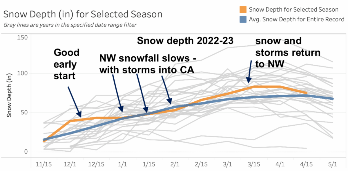
The third La Nina in a row promised another great snow season. And yes, once again La Nina delivered for the NW, with cold and snowy conditions. However, most of the heaviest and consistent snowfall went south into California with record deep snowfall. The storm track this past season was often aimed at northern and central California. La Nina did transition to neutral in February and March, which may have been a factor in our total snowfall in some areas.
The winter outlook was for near-to-above-normal snowfall, and most NW ski areas were in that range. Whistler, Stevens, and Baker were a little light with their total snowfall, yet skied well with consistently cold temperatures. Most other areas were very close or above average. The Inland NW did especially well. Powder Poobah sponsors 49 Degrees and Silver Mountain saw above normal snowfall, with an extra chill producing quality snow to polish those primo powder days – and extend the season, still in progress!
Overall, I think the most important weather bonus for the NW with La Nina was the consistent cold. As the storm track aimed south into California, we were on the cold northern side of the jet stream. We had very few warm spells or extended dry spells – which made skiing consistently very good. I had a lot of days that were 9’s or 10’s, just because the snow was high quality (cold, dry). And thanks to good grooming, which was an added bonus.
The graph below (NWAC) shows how the season progressed, based on Crystal snowfall.
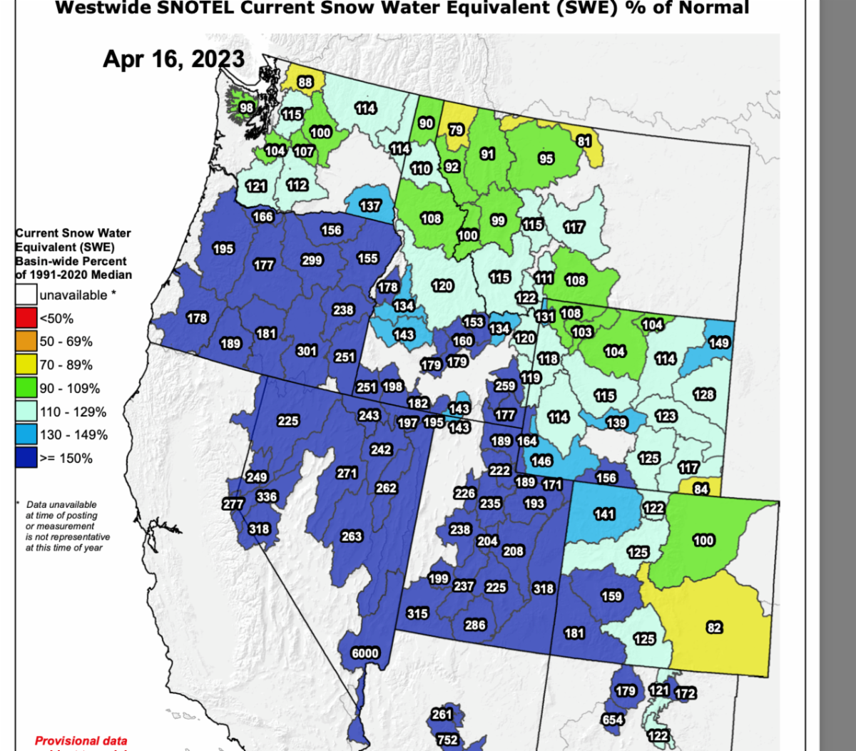
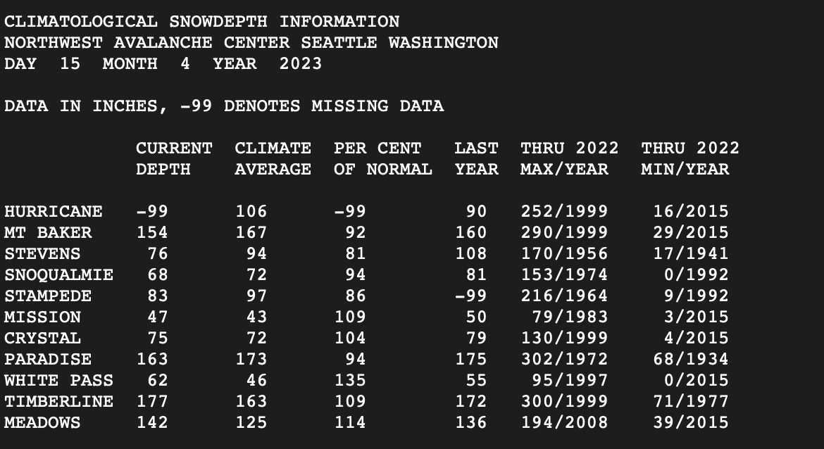
In the map below is the snowpack for April 16, 2023. We have a NW snowpack that is near to above normal, but some areas near the Canadian border are below normal. In the table below is snow on the ground for the NW ski areas. This is a mixed bag with some areas near normal while some are above normal and other areas are slightly below normal.
From the Grand Poobah of Powder
Next season: 2023-24, probably El Nino
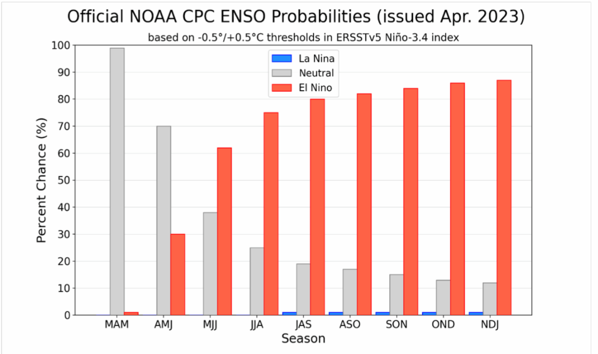
Although we typically hesitate to call next season this early, it appears the 2023-24 season will be El Nino and possibly a strong one. The higher-than-normal confidence is related to the recent, rare three-year extended visit from La Nina. Eventually, it always flips back, so it’s overdue. Plus, all the ocean/atmosphere computer modeling shows El Nino is up to the plate for winter 2023-24.
In the mid-tropical Pacific Ocean, very large warm and cold pools of water slosh back and forth. Tropical weather shifts with these huge warm/cold blobs of ocean water. After a three-year slosh toward cool (La Nina), it’s likely it is going back to warm (El Nino) in a big way. Tropical ocean and air currents are connected to our mid-latitude winter storm tracks. Those connections affect the weather where we live and play. The tropical to mid-latitude weather link can favor abundant NW snowfall, normal snowfall, or the infrequent lean winter snow season. That’s why we use El Nino or La Nina to give us a hint of what to expect months in advance – but the linkage is not perfect and always shows variations. There are no guarantees.
El Nino is probable next season. El Nino does tend to focus the winter storm track on California, not on us. That doesn't mean no snow, just fewer storms. But there are many exceptions and modifications – look at this past season as an example of an exception. California’s Sierra Nevada getting clobbered with much of “our” La Nina snowfall.
To be honest, we’ve had a few dogs with El Nino. The NW winter of 2005 (marginal snowfall until late) and 2015 (normal precipitation, but consistently high snow levels). But many El Nino winters are near normal.
Remember, El Nino and La Nina do not dictate the weather. They only tilt the odds. Like loaded dice, it’s not a guarantee of any specific result. El Nino tends to keep the snowfall below normal for the NW, but not a bust. Remember too, there are other factors like long-term (10-year) trends which also factor into the seasonal outlooks.
Those trends with climate change are warming – we are lucky we got a good cold one this past winter. It shows natural variations remain an important factor. However, cold winters are becoming less frequent along the West Coast.
The graph below shows modeling favoring a quick transition to El Nino, next season.
The Grand Poobah of Powder
Concluding Remarks
We’ll have a few more forecasts. There is still good skiing, so go for it. We’ll have an El Nino update in the late summer or early fall.
A big thanks to all our sponsors. Please support them. They make this Powder Alert happen. And, also, thanks to Michael and Andrea.
The Grand Poobah of Powder
Larry Schick
Meteorologist
Check out the NW Weather Workshop: (sponsored by UW and NOAA) I’ll be speaking about this winter compared to the great winter of 1861-62. Plus, there will be other interesting NW weather topics (May 12-13).
See you out there, because there are plenty of snow fans who aren't done yet!


